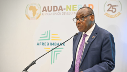
Nairobi, Kenya, 6 November 2026 – Experts from space agencies, ministries of agriculture, national statistical offices across Africa gathered in Nairobi from 2 to 6 November for the second regional workshop of the Earth Observations for Crop Data (ESTELLA) programme. The session aimed to strengthen the use of satellite-based technologies to improve agricultural data and support evidence-based policymaking through the integration with Farmer Registries.
Organized by the Food and Agriculture Organization of the United Nations (FAO) and the United Nations Economic Commission for Africa (ECA), in collaboration with the European Space Agency (ESA) and the Kenya Space Agency (KSA), the five-day workshop combined practical training, country experience sharing and strategic discussions on integrating Earth Observation (EO) data into national agricultural statistical systems.
The event opened with remarks from representatives of FAO, ECA, KSA, the Kenya National Bureau of Statistics (KNBS), ESA and the European Union, highlighting the importance of institutional collaboration and innovation in strengthening agricultural data systems across the region.
In his opening remarks, George Yalla from the Cartography/GIS Division at KNBS, emphasized the importance of crop statistics for informed decision-making: "Crop statistics provide critical information for formulating evidence-based policies and programmes, and for the budgeting process. When we know how much is planted and what will be harvested, we can plan for food security, markets and farmer support."
Turning satellite observations into reliable agricultural statistics
Through ESTELLA, FAO and ECA are working with national institutions to strengthen their capacity to produce timely, reliable and reproducible crop areas and yield estimates using satellite-based technologies.
The programme supports countries with integrating EO data into agricultural data and statistics and farmer registries, helping bridge information gaps and improve the evidence available for agricultural planning, food security monitoring and policy decisions.
Highlighting the importance of translating technological innovation into practical applications, Charles Mwangi, Technical Director at KSA stated: “Combining Earth Observation tools with in-situ data and robust farmer registries, Kenya is seeking to actively bridge the gap between advanced satellite analytics and practical agricultural policymaking."
"Ultimately, the aim is to deploy operational services that would make agricultural information readily available to policymakers and farmers,” he added.
A central component of the workshop was hands-on training in Sen4Stat and Sen4CAP, two EO-based frameworks designed to support crop monitoring and agricultural data applications.
Led by experts from the Université catholique de Louvain (UCLouvain), the sessions allowed participants to work directly with national datasets, exploring crop mapping, field boundary delineation, sampling design and data validation.
Zoltan Szantoi, Land Applications Scientist at ESA explained: “We do not only build rockets and satellites; we also build downstream data solutions. WorldCereal and SEN4STAT, as two flagship projects, have delivered free and open pre-operational systems for crop detection and yield estimation globally. We are excited to see that FAO builds on these systems and uses them operationally."
Alice Gwedeza, Manager of Earth Observation and GIS at the Regional Centre for Mapping of Resources for Development (RCMRD), reflected on the training:
“This workshop has been an eye-opener. In Africa, we depend on agriculture, and there are many factors affecting food security. Observing from space is one thing, but how do we interpret that data to make it meaningful and support decision-making? The open-source tools presented will be very helpful to participating countries and can be shared more widely across Africa.”
The training also introduced WorldCereal, a satellite-based crop mapping system developed with support from ESA. Participants explored how to generate cropland masks, manage reference data, develop crop classification models and translate satellite observations into crop area estimates.
Sharing country experiences and strengthening regional cooperation
The workshop brought together experts from ESTELLA pilot countries like Kenya, Senegal and Zimbabwe, alongside representatives of national institutions and regional centres of excellence.
Country teams shared progress in applying EO technologies to agricultural monitoring, including crop type mapping and the integration of satellite-derived information with national farmer registries. These experiences provided opportunities for peer learning and identifying practical approaches that can be adapted and scaled up across the region.
Beyond technical training, the programme addressed the institutional requirements for sustaining EO-based agricultural statistics, including data quality, validation procedures, governance and long-term operational capacity.
From technical training to national action
The workshop concluded its first three days with country action-planning sessions for Kenya, Senegal and Zimbabwe, focusing on practical next steps for integrating EO technologies into national systems.
Discussions also contributed to an Eastern Africa regional roadmap, covering institutional arrangements, standard operating procedures and opportunities for collaboration between national authorities, regional institutions and technical partners.
The final two days focused on WorldCereal training, providing participants with additional practical experience in satellite-based crop mapping, model development and validation.
By combining technical capacity development with country-led planning and regional cooperation, ESTELLA aims to support the sustainable integration of EO technologies into farmer registries, contributing to more informed agricultural policies and improved food security across Africa.